Home ยป Forum ยป Author Hangout

Forum: Author Hangout

How Far is a Mile?

PotomacBob ๐Ÿšซ

When hiking in mountains, with lots of ups and downs, and curves, how far is a mile? I've been told that they measure miles horizontally, and that if you took a measuring tape, the actual mileage walked could be almost twice as much as far as the mileage measured horizontally.
Anybody know?

CB ๐Ÿšซ

@PotomacBob

A miles a mile. Walking in extreme hilly terrain would be walking hard miles.

Trail or road miles are different. They chart the distance traveled as opposed to how far the crow flies. Why crows get the job I do not know.

Replies:   Dominions Son
Dominions Son ๐Ÿšซ
Updated:

@CB

Why crows get the job I do not know.

Because crows fly longer distances in straight lines than most other common non-migratory birds?

ETA: it made me curious and I found this:

https://www.worldwidewords.org/qa/qa-ast1.htm

Or this from Quora is probably more likely:

https://www.quora.com/Where-does-the-phrase-as-the-crow-flies-comes-from-What-does-it-really-mean

Until the development of airplanes, people going from one place to another had to follow the irregularities of the earth beneath them. Only birds could fly in a straight line. As to why the crow is given as an example, I can only hypothesize that it's because the crow is a common bird with a short name in English. The first written usage dates back to the mid-18th century.

Dominions Son ๐Ÿšซ

@PotomacBob

How Far is a Mile?

Pedantic answer: 5280 feet.

Replies:   samuelmichaels
samuelmichaels ๐Ÿšซ

@Dominions Son

Pedantic answer: 5280 feet.

Unless it's a nautical mile. Or Roman, Italian, Chinese, or US Survey mile ...

Replies:   Remus2
Remus2 ๐Ÿšซ

@samuelmichaels

Unless it's a nautical mile. Or Roman, Italian, Chinese, or US Survey mile ...

Chinese traditional mile Li= 1640 feet or 500 meters. The rest are ~ of a standard imperial mile.

AmigaClone ๐Ÿšซ

@PotomacBob

Alternatively a mile is 1609.344 meters.

Now, as mentioned before, two points might be a mile apart in a straight line, but the shortest path or road between those two points might be several miles long due to the turns and changes in elevation between those two points.

Ernest Bywater ๐Ÿšซ

@PotomacBob

How you measure the mile depends on how you're traveling. Go by air and it's the straight line distance between the start point and the current location, go by foot or vehicle and it's 5,280 feet along the path you take and it includes the ups, downs, and turns. In hilly or mountainous terrain a mile of walking is likely to have you end up only a few hundred feet in straight line travel from where you started. It's not uncommon to see an bridge of a few hundred feet in length can span the space between two ridges and the distance by path down into the ravine and up the other side between the two ends of the bridge could be a couple of miles apart by land.

Remus2 ๐Ÿšซ

@PotomacBob

When hiking in mountains, with lots of ups and downs, and curves, how far is a mile? I've been told that they measure miles horizontally, and that if you took a measuring tape, the actual mileage walked could be almost twice as much as far as the mileage measured horizontally.
Anybody know?

Perspective is everything. Looking at a flat map, and its scale, what appears to be a mile, may require two or more actual miles to transverse.

irvmull ๐Ÿšซ

@PotomacBob

The shortest distance between two points is a straight line.
Go up and down hills, and it's no longer a straight line.
3rd grade geometry: https://www.k5learning.com/free-math-worksheets/third-grade-3/geometry/perimeters

Replies:   StarFleet Carl  joyR
StarFleet Carl ๐Ÿšซ

@irvmull

The shortest distance between two points is a straight line.

Incorrect. The shortest distance between two points is to fold space so that the two points touch.

Replies:   Dominions Son  irvmull
Dominions Son ๐Ÿšซ

@StarFleet Carl

The shortest distance between two points is to fold space so that the two points touch.

Technically, that's still a straight line, it's just very short. :)

irvmull ๐Ÿšซ

@StarFleet Carl

Incorrect. The shortest distance between two points is to fold space so that the two points touch.

Somewhat easier said than done.

joyR ๐Ÿšซ

@irvmull

The shortest distance between two points is a straight line.

It is no longer acceptable to classify lines as 'straight', any description of lines must be gender fluid. Curved, wavy, wiggly etc as well as spiral lines may self identify as 'straight'. And vice versa.

:)

Replies:   Ernest Bywater
Ernest Bywater ๐Ÿšซ

@joyR

It is no longer acceptable to classify lines as 'straight', any description of lines must be gender fluid. Curved, wavy, wiggly etc as well as spiral lines may self identify as 'straight'. And vice versa.

Don't forget they're also allowed to be transgender now, depending on what they feel like being.

awnlee jawking ๐Ÿšซ

@PotomacBob

Put someone else's shoes on and start walking. When you understand what they're thinking and feeling, you've walked a mile ;-)

AJ

happytechguy15 ๐Ÿšซ

@PotomacBob

Hiking in mountains...
Two years ago wife and daughters tried to toughen me up for hiking in our planned rocky mountain no vacation. Central Indiana hiking? Yes, we all thought we were ready. HA! Those mountain miles are longer! "Y'all go on up, wheeze, I'll see you on the way, wheeze, down".

irvmull ๐Ÿšซ

@PotomacBob

People tell me biking to town would help "save the environment".

It would be easy, since it's downhill all the way.
And uphill, 1,200 ft. in elevation, on the way back.

Probably right - one trip, and I'd stop breathing, eating, and otherwise using resources altogether.

Replies:   Dominions Son
Dominions Son ๐Ÿšซ

@irvmull

If only you could rig up something like a rope tow ski lift to pull your bike back up.

Replies:   Not_a_ID
Not_a_ID ๐Ÿšซ

@Dominions Son

If only you could rig up something like a rope tow ski lift to pull your bike back up.

That was the first generation ski-lift. No chairs, just ropes hanging down from a pulley system. You grabbed onto the rope and it pulled you to the top of the mountain while you slid along on your skis.

Switching to chairs eliminated people falling down in front of you, and allowed people to move downhill under the people the making their way uphill, as well as a number of other considerations. (People's arms weren't likely to be as sore/tired after being literally dragged up a mountain by their arms, and so on)

Replies:   Dominions Son
Dominions Son ๐Ÿšซ

@Not_a_ID

That was the first generation ski-lift.

From what I could find, there are a few places where they are still in use.

Torsian ๐Ÿšซ
Updated:

@PotomacBob

A mile is subject to interpretation and need. Are you estimating travel time? Describing distance to someone not there? Watching your car's odometer and dwindling supply of gas? Wondering how long until you get off your aching feet? As with anything the meaning of numbers can be twisted by creative smart asses as much as a thread here with out the proper context and heavily armed guards.

Replies:   Radagast
Radagast ๐Ÿšซ

@Torsian

heavily armed guards.

Only on The Green Mile.

Mushroom ๐Ÿšซ

@PotomacBob

When hiking in mountains, with lots of ups and downs, and curves, how far is a mile? I've been told that they measure miles horizontally, and that if you took a measuring tape, the actual mileage walked could be almost twice as much as far as the mileage measured horizontally.

It can certainly feel that way, but it really is not.

The most simple way is to find a topographical map of the route. That will have elevation lines on it, generally each line is 20 meters.

https://www.worldatlas.com/r/w960-q80/upload/f4/9a/b2/shutterstock-214460839.jpg

Look at the legend at the bottom, as it may vary and is not always 20m. Then simply count the number of lines crossed, multiple that by the gradient and add it to the distance.

Replies:   Remus2
Remus2 ๐Ÿšซ

@Mushroom

That's one of those post that needs graphics support to realize it's potential.

Replies:   Mushroom
Mushroom ๐Ÿšซ

@Remus2

That's one of those post that needs graphics support to realize it's potential.

It really is not, as I have trained countless Privates in how to do just this.

In the example above, assume you are starting in about the center, where the black "552.1" is located. And then follow the road to the east until it meets the next road. By looking at the altitude indicators, each elevation line is 10 meters. When you simply count the lines crossed, in this case it is 8. Then you simply a88 8 times 10 for the distance traveled (in this case downhill) and add that to the straight line distance traveled.

I guess this is where having a military background comes in handy, as I have been doing this without thought for over 40 years now. Topo maps are amazing, and actually almost free for every square inch of the US through the USGS.

Replies:   BlacKnight  Remus2
BlacKnight ๐Ÿšซ

@Mushroom

The hypotenuse of a triangle is not the sum of the legs.

Replies:   madnige  Mushroom
madnige ๐Ÿšซ

@BlacKnight

From Pace (unit)

The Ancient Roman pace (Latin: passus) was notionally the distance of a full stride from the position of one heel where it raised off of the ground to where it set down again at the end of the step: two steps, one by each foot. Under Marcus Vipsanius Agrippa, it was standardized as the distance of two steps (grad?s) or five Roman feet (pedes), about 1.48 meters or 4 feet 10 inches. One thousand paces were described simply as mille passus or passuum, now known as a Roman mile; this is the origin of the English term "mile".

So, in the most basic form, a mile is a thousand paces (this matches what I remember from reading as a kid). However, as the ground changes away from level, your steps/paces naturally become shorter, so summing the lateral and vertical distances rather than doing a Pythagorean calculation is quite reasonable.

Don't make the mistake of thinking that the stride should lengthen going downhill: think of taking stairs in a hurry. You'll probably hit every other step going up, but be very leery of skipping any coming down. I once tried sprinting down a hill, and was barely able to keep my legs/feet in a position to avoid falling, and had no hope of getting them far enough forward to slow or stop. I stopped by deliberately running into a lamppost and hugging it, and clocked my pulse at approx 230-240BPM whilst gasping for breath (although it did slow dramatically over the next minute or so).

Replies:   awnlee jawking
awnlee jawking ๐Ÿšซ
Updated:

@madnige

Don't make the mistake of thinking that the stride should lengthen going downhill

Actually I was making the 'mistake' of thinking that, in many conditions, the stride should lengthen going uphill.

In any case, I don't see how the length of a stride affects the actual distance traversed. Assuming the travel is in a single compass direction, I would expect the actual distance to be somewhere between the length of the hypotenuse and the lengths of the other two sides added together.

Then there's the 'coastline of Norway' argument which claims that the distance travelled is infinite ;-)

AJ

Replies:   Mushroom
Mushroom ๐Ÿšซ

@awnlee jawking

In any case, I don't see how the length of a stride affects the actual distance traversed. Assuming the travel is in a single compass direction, I would expect the actual distance to be somewhere between the length of the hypotenuse and the lengths of the other two sides added together.

In theory that is all well and good. But it is also trying to solve a problem in two dimensions when it is really in three dimensions.

One thing those of us "ground pounders" are aware of is our "pace count". We always make two of them. One along a 100 meter course that is flat and even, like a road. That is our "normal pace count". We then repeat this along uneven ground, with variations both up and down (normally 1-3 meters), that is our "rough terrain pace count".

My flat pace count is 63 paces per 100 meters. My rough terrain pace count is 68 per 100 meters. And 5 "paces" may not sound like much, but remember a pace is your left AND right foot hitting the ground, so that is 10 steps.

Over 1 kilometer, that is 50 paces or 100 steps different. And in long distance land navigation courses (500-700 meters per leg), my pace count is accurate to within 3-4 steps. This was true in the jungles of Panama, the woods of North Carolina, and the desert of Southern California and Texas.

Mushroom ๐Ÿšซ

@BlacKnight

The hypotenuse of a triangle is not the sum of the legs.

But it is not a triangle. It is trying to closely estimate with visual representations a three dimensional traverse from a two dimensional depiction.

Trust me, I have been doing this for decades. It can never be exact, as not every aspect even on a map is "perfect". Especially as the maps normally give increments in 10-20 meters, and does not even count in any additional changes that might happen in the distance between contour lines. But it is far closer than just the distance taken alone without adding the additional vertical distances figured in.

The only way to be "100% correct" is to physically walk the route with a measuring wheel. We do use those on occasion, but really only for things like PT courses where the distances have to be exact to the inch.

awnlee jawking ๐Ÿšซ

@Mushroom

The only way to be "100% correct" is to physically walk the route with a measuring wheel.

But you'll get a different *100% correct* measurement with a different circumference wheel.

AJ

Replies:   Dominions Son
Dominions Son ๐Ÿšซ

@awnlee jawking

But you'll get a different *100% correct* measurement with a different circumference wheel.

You shouldn't if the linear distance to revolutions is calibrated correctly for each.

Replies:   awnlee jawking
awnlee jawking ๐Ÿšซ

@Dominions Son

You shouldn't if the linear distance to revolutions is calibrated correctly for each.

Only it the surface is perfectly flat. And in the scenario in question, it isn't.

AJ

Replies:   BlacKnight
BlacKnight ๐Ÿšซ

@awnlee jawking

This runs into what's called the fractal dimension of the terrain. The wheel can't measure features that have a tighter curve than the curve of the wheel's outer edge, so as the terrain gets rougher, you get a larger and larger difference between what a small wheel will measure and what a big one will.

As an extreme example, imagine that there happens to be a posthole, 6 cm wide and a meter deep, directly along the path you're measuring. If your measuring wheel has a 5 cm diameter, it will drop down into the hole, measure a meter down one side and another meter back up the other, in addition to the distance across the hole. If you're using a 20 cm wheel, however, it will just dip a couple millimeters as it rides over the hole without dropping in. A 1 meter wheel will dip even less. The small wheel will give a measurement almost 2 meters more than the large one.

In practice, though, if we're talking about actual walking distance over the terrain, this isn't really a factor. As long as you don't actually step in the posthole (and if you do, you have other problems), your stride will smooth the terrain contours the same way the larger wheel does.

Replies:   awnlee jawking
awnlee jawking ๐Ÿšซ

@BlacKnight

This runs into what's called the fractal dimension of the terrain.

The coast of Norway.

AJ

Replies:   Radagast
Radagast ๐Ÿšซ

@awnlee jawking

I blame Slartibartfast.

Replies:   Remus2
Remus2 ๐Ÿšซ

@Radagast

I blame Slartibartfast.

Not even Slartibartfast would torture a coastline that badly.

BlacKnight ๐Ÿšซ

@Mushroom

But it is not a triangle. It is trying to closely estimate with visual representations a three dimensional traverse from a two dimensional depiction.

It is, in fact, a triangle. The map distance gives you a horizontal distance. The contour lines give you a vertical distance. That gives you two vectors โ€” both distance and direction โ€” at right angles to each other. Those vectors form the two legs of a right triangle. The actual three-dimensional distance between the points is the length of the hypotenuse of that triangle. And, as I said, the length of the hypotenuse is not the sum of the legs. It is, per Pythagoras, the square root of the sum of the squares of the legs.

For example, if you walk 4 km map distance up a constant slope that rises 200 meters over that distance, the actual distance you have traveled is not 4000 + 200 meters. It's โˆš(4000ยฒ+200ยฒ) == 4005 meters.

The sum of the legs is the upper bound of the length of the hypotenuse (the lower bound is the length of the longer leg), and only accurate as one leg or the other approaches zero โ€” if you're traveling across a perfectly flat plain or climbing a vertical cliff.

Of course, simply finding the three-dimensional distance between the start and end points is only exact for a constant, smooth slope. For more complex curves, you can get better approximations by breaking the calculation up into the sum of a series of smaller ones โ€” the smaller, the better. (This is the basic premise behind calculus.)

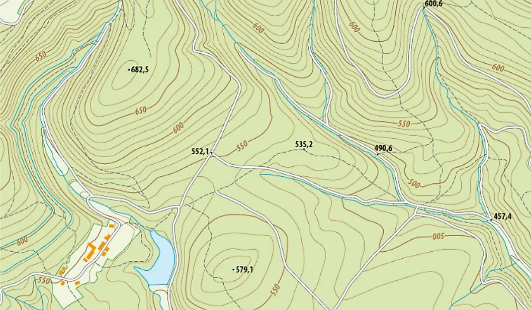
If you're measuring on a topo map, in practice the accuracy of the approximation will be limited by the resolution of the contour lines. The best approximation you'll be able to get is measuring the distance between each successive pair of contour lines along the path and calculating the hypotenuse of the triangle with the base the distance between lines and the altitude the contour resolution, then sum all of those small approximations.

In theory, you can imagine making those measurements closer and closer together, until they're infinitesimally small and the series of tiny hypotenuses exactly conform to the terrain.

Trust me, I have been doing this for decades. It can never be exact, as not every aspect even on a map is "perfect". Especially as the maps normally give increments in 10-20 meters, and does not even count in any additional changes that might happen in the distance between contour lines. But it is far closer than just the distance taken alone without adding the additional vertical distances figured in.

The Marines taught you a method of making a rough approximation that you can do in the field without needing to have a calculator or figure square roots in your head. It may even be more useful for figuring the difficulty of traversing the terrain than the actual geometric distance. But that doesn't mean that it's an accurate measurement of the actual distance, which is what we're talking about here.

Replies:   Mushroom
Mushroom ๐Ÿšซ

@BlacKnight

For example, if you walk 4 km map distance up a constant slope that rises 200 meters over that distance, the actual distance you have traveled is not 4000 + 200 meters. It's โˆš(4000ยฒ+200ยฒ) == 4005 meters.

And most terrain is not a perfect even slope, but is both up and down. Where you are constantly going up and down.

file:///C:/Users/mushr/Downloads/NH_Wolfeboro_20180707_TM_geo.pdf

But let me ask, how much of this "experience" is just in looking at information and largely theoretical, and how much is actually "boots on the ground" by actually doing it?

There is a huge difference between a thought exercise, and actually doing it.

https://www.loc.gov/resource/g3954f.ct010494/?r=0.311,0.233,0.358,0.248,0

What you are saying is correct, if talking about only about relatively short distances on a road or other flat smooth surface. When talking about real world terrain and hiking it on foot, it is very different. Terrain goes up, down, even sideways. Contour lines are only mean approximations, and does not take in the variations between the lines.

Heck, that can be obvious here:

file:///C:/Users/mushr/Downloads/NH_Wolfeboro_20180707_TM_geo.pdf

Where in grid square 2423 you literally have a large area which is essentially a cliff.

But feel free to claim whatever you want, I was giving real world examples and how to figure it.

Replies:   Remus2
Remus2 ๐Ÿšซ

@Mushroom

file:///C:/Users/mushr/Downloads/NH_Wolfeboro_20180707_TM_geo.pdf

Umm you might want to point to an Internet source, rather than on your home system.

Replies:   madnige
madnige ๐Ÿšซ

@Remus2

NH_Wolfeboro_20180707_TM_geo.pdf

Here you go:
https://prd-tnm.s3.amazonaws.com/StagedProducts/Maps/USTopo/PDF/NH/NH_Wolfeboro_20180707_TM_geo.pdf

Remus2 ๐Ÿšซ
Updated:

@Mushroom

It really is not, as I have trained countless Privates in how to do just this.

I'm a regular user of topo maps. Especially since they used to be cheap in Tennessee. I have the entire state of TN in topographic maps, and a good portion of the Appalachian trail as well. My old man taught me landnav the army way when I was eight. The training you state having performed wouldn't have happened without the map in front of the privates. That map is the necessary graphic to teach the subject. Even you recognized the need by posting a link to a topo example.

Replies:   Mushroom
Mushroom ๐Ÿšซ

@Remus2

Especially since they used to be cheap in Tennessee.

Actually, they are "free" for all of the US.

https://store.usgs.gov/

There you can find 1:25000 or 1:50000 maps of almost every square inch of the US. They are completely free to download, but on average are $15 if you want a physical copy.

And if you know anybody with a large format plotter or are willing to print and tape them together yourself it is still essentially "free". And a great many print shops can print them for you, but the cost there is up to them. I had some about 20 years ago that I had printed, and I want to say they cost me around $8 each (for the Vasquez Rocks area in Southern California).

And for any that want to give a problem saying it is "copyrighted", tell them that as an item available from the GPO it is considered "public domain", so printing for personal use is allowed. You simply can not print them for resale.

I have used these a great many times over the years, especially the time my wife bought a gold claim on the Kern River near Bakersfield. The seller was smart enough to just use a highway map to show where it was, and she bought it based on that.

Only telling me she had bought it afterwards. When I went to the USGS site, downloaded the map, and saw that the claim was literally at the bottom of a cliff.

I did walk down to it once, and it was a royal pain in the ass with a drop of over 30 feet in the last 20 horizontal meters. She saw how steep the slope was (about 45 degrees) and never did walk down to see the claim she had bought.

Replies:   Remus2
Remus2 ๐Ÿšซ

@Mushroom

Getting a clear crisp copy printed is necessary. As you should know, smudged lines can screw you over in land navigation. At the time I aquired my set, that was not generally a cheap option.
In today's time, topographical maps have largely fallen to the wayside due to wide spread GPS use.
My son wasn't a happy camper the first time I taught him. I took his GPS and phone, stuck them in a bag, then hide them under a rock five miles away in the woods. I gave him a lensatic compass, a marked topo map and told him to go retrieve his other gear. He learned.
Everyone who ever hikes should know how to do it for a backup in the event their electronics die.

Replies:   Dominions Son
Dominions Son ๐Ÿšซ

@Remus2

Everyone who ever hikes should know how to do it for a backup in the event their electronics die.

Or run out of bat treats. :)

mauidreamer ๐Ÿšซ

@PotomacBob

The origin of "mile" as a distance measurement comes from ancient Rome. To be more specific, from the Roman Legions from their mille passus, literally "1000 paces", which they marked by stakes every 'mile' along their route of march.

To the legion, actual distance covered was less important than how much marching was necessary. Uphill "miles" were shorter distances but still required same marching time/effort to accomplish.

TechnicDragon ๐Ÿšซ

@PotomacBob

when you go hiking take a surveyor's wheel. It's a single wheel on a stick with a counter on the handle. You roll the wheel along the ground as you hike and the counter tells you how far you've traveled in feet or meters, depending on where you get it. refer to others measurements for meters per mile, but I know 5280 feet is one mile. The only real way to be certain how far you've traveled!

Back to Top

Close
 

WARNING! ADULT CONTENT...

Storiesonline is for adult entertainment only. By accessing this site you declare that you are of legal age and that you agree with our Terms of Service and Privacy Policy.